Antalya's Architectural Texture From the Past to Present
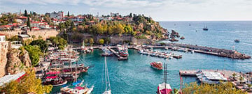
 Antalya, according to the rumors, was founded in the 2nd century by the name of Attaleia where today's marina is located in Kaleiçi by King of Pergamum II. Attalos saying “Find me heaven on earth” or according to some sources, by him failing to take Side, which is one of the most strategic port cities in the Mediterranean. It is believed that during the Hellenistic Period, the settlement of Attaleia had a size that encircled today's Kaleiçi Port and that it extended to the present-day Mermerli and Tophane terraces in the north and south and to the Yivli Minare in the east. Excavations done in the Kesik Minare area indicate that the area was used as an “agora” and that the settlement reached to there in the time of II. Attalos. Tower of Hıdırlık, which was used for defense or as a lighthouse and survived until today, was also built during this period. It is believed that the fortification walls extending from Kırk Merdiven to the Castle Gate, which provide the passage between the harbor and the city, have been standing for centuries and were built during the Hellenistic Period. By Attaleia, which changed hands frequently between the Hellenistic Kingdoms, being “visited” by the Roman Emperor Hadrianus around A.D. 130 many ostentatious buildings were built to honor the emperor’s arrival. The most well-known in the present day from these structures is the Hadrian's Gate.
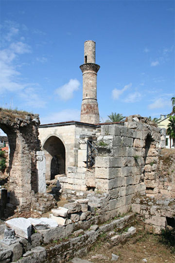
By the Roman Empire M.S. accepting Christianity as the legal religion from the 4th century onwards caused major changes in the urban structure of Attaleia, and most of the buildings belonging to previous religions were destroyed during this period. It is believed that most of the dozen churches mentioned in the early 20th century were built during this period. The most important of these churches is the Panagia Church, which is known as the Kesik Minare today.
Attaleia attracted immigrant groups who left the big cities like Perge and Termessos due to the Arab invasions that reached to the region during the Early Byzantine Period with its strong walls. The arriving of immigrants caused the need to strengthen the defense system of the city. Hadrian's Gate became a part of the defense system, the walls were extended to the east and south, and ditches filled with water were excavated between the inner and outer walls. It is believed that the organized architectural texture of Attaleia, which was composed of wide streets, deteriorated due to the need for shelter in this period and became today's narrow and erratic streets.
Turkish dominance increased in the region hence the 12th century and Attaleia changed hands between the Byzantines and Seljuks for a while, and after 1216 it became a city of Seljuks. Since this period, the population of Turkmens has started to increase in the region. In later times, with the increment of the Turkish population in the city, the Christian population was pushed to the outskirts. During this period, many monuments such as Yivli Minare Mosque which is the oldest multi-domed mosque in Anatolia, Zincirkıran and Nigar Hatun Tombs, were built.
In the 15th century, during the period when Antalya was the capital of the Teke Principality, many dervish lodges, zawiyas, madrasahs and fountains were built in the region. After joining the Ottoman Empire in 15th and 16th century, as a result of the economic mobility in Anatolia the city spread out of the walls, in time, the inner castle became a region where port workers and administrators lived. According to the urbanization understanding of the Ottomans, a newly built mosque constitutes the core of a desired new settlement. Based on this, we can say that Bali Bey Mosque which was built in the second half of the 15th century and Murat Paşa Mosque built by Karaman Beylerbeyi Murat Paşa, in 1571, encouraged people to settle outside the walls. During this period, the city began to be known as Adalya, lost the feature of being a wall-surrounded city of the Byzantine and Seljuk period and was impersonated into an Ottoman city.
When Evliya Çelebi visited Adalya in 1671, he wrote that the city walls were 4400 steps long, accommodated 80 towers and that it encircled a settlement of about 3000 houses with narrow streets. In his notes, Adalya evokes the impression of a crowded port city overflowing beyond its walls. It can be said that Anatolia entered an immobile age as a result of the central authority weakening due to political events such as Jelali Revolts, social and political turmoils, disintegration of manorialism beginning from 17. and 18. Century. This explains the fact that the only monumental building in Adalya built in the 18th century that has survived to this day is the Tekeli Mehmet Pasha Mosque. At the same time, as the Atlantic trade became stronger, Adalya fell back in terms of sea trade as the Mediterranean trade lost its old importance.
Admiral Francis Beaufort stated in his visit to Adalya in 1811 that the town was settled around a small harbor, its streets rose up one after another like a theatre’s steps, it had one ditch, two sets of fortification walls, it was equipped with a series of quadrilateral towers and had a population not passing 8000 people.
As a result of the Ottoman society falling behind of Europe in the 19th century in meanings of economy and technology, a series of reform studies were conducted. The process of reform on political, social and economic sections started with the Tanzimat Edict, which is the most important part of the reform studies, affected port and trade cities where the trading was dense. Antalya was among these cities, but the fact that this region is not connected to Anatolia by rail has prevented this city developing as much as Istanbul, Izmir and Bursa. Towards the end of the 19th century public buildings such as government mansions, hospitals, schools, police stations and besides these structures, as European countries gained control over eastern trade, customs, warehouses, post offices and foreign banks were established. Karl Lanckoroński, who visited the city in 1885, stated that there were approximately 25,000 inhabitants, 10 mosques, 9 churches, 2 hospitals, 1414 shops and 6-7 schools in Adalya. This information proves that the city was affected by the reforms of the Tanzimat Period. Towards the end of this year, Antalya was far from being a small city surrounded by walls. The city had a population of 25,000 and expanded to the Elmalı, Teşvikiye and Muratpaşa neighborhoods in the north of Kaleiçi as well as Balbey and Yenikapı neighborhoods in the east.

The beginning of the 20th century had been quite turbulent for Anatolia. During World War I and War of Independence, Antalya suffered a great deal of economic damage just like other Anatolian cities. The region was under the attack of Italians for some time. At the same time, Kaleiçi had ceased to be the most important settlement of the city as a result of events such as getting damaged by fires in the last two centuries, demolishing the majority of the walls due to the fact that it no longer worked in terms of security and preventing the air circulation of the city, and the migration of the Greek part of the city by exchange.
In the period starting from the proclamation of the Republic of Turkey up to 1950’s, small towns were chosen for the factories to be built under the industrialization plan as a part of the modernization project which aimed for enlarging and creating modern cities. During this period, although the cities other than Ankara did not grow much, structures such as Antalya High School, which is still continuing to educate in Antalya, and Community Center were built. Historical, cultural and economic development of Antalya has been discussed in detail in some of the works in recent years. The wooden shops around Kalekapısı were demolished, modern single-story buildings were built, palms were planted on Ataturk Street, Karaalioğlu Park was renovated, Konyaaltı Street was opened and the district of Bahçelievler, which developed parallel to the street, became one of the first planned zoning acts in the city. At the same time, the Maiden's Tower, which was used as a landmark at Kaleiçi Port during this period, was demolished by the order of the Governor of Antalya Sadri Aka despite the objections of the Mayor Burhanettin Onat.
The 1950’s, following right after the Second World War raged in Europe, on the contrary, has been a turning point for Turkey’s urbanization process. Starting from this period, a migration from the rural population to the city began in Turkey as a result of Turkey now being open to foreign countries economically, a rapid mechanization in agriculture, the average life expectancy prolonging and a desire to live in better living conditions. In 1950, the central population of Antalya was 27,000 people and the spread area was 270 hectares, in only 10 years the population had reached 50,000 people and the spread area was 690 hectares. While the infrastructure of the city was attempted to be completed as the technology of that period allowed, important industrial initiatives such as the establishment of Antalya Cotton Weaving Factory and Kepez Power Plant were made in the city. During this period, Antalya had spread to Konyaaltı beach in the west, Barınaklar district in the south and Dokuma and Memurevleri in the north. This period features the last years in which the growth of Antalya could be kept under control. During this period, the first city plan of Antalya was created in 1957. Although a coherent development strategy was put forward in the plan, the intense population growth could not be predicted and the original architectural texture and climate characteristics of the city were not taken into consideration. For this reason, an irreversible construction process had started in Antalya.
As mentioned above, Antalya's population had reached 50.000 by a sudden jump in 1960. With a cascading increase, the population of the city had reached 95,000 in 1970. In order to meet the housing needs of the exponentially growing population, apartments began to be built in big cities including Antalya. After Antalya’s first apartment, “Forty Apartments” were built in Işıklar in 1964, other apartments started to rise in Güllük Street in the 70s, and in the same period the prohibited construction of illegal houses in Kepez were condoned by the governance. Then more buildings began to rise rapidly in Antalya, the old neighborhood life was lost, the increase in rent around the city center's old town texture and as a result of this, many business shops were built and the main streets were transformed, and the city slowly lost its identity. The historian Hüseyin Çimrin, who is known as “the living memory of Antalya”, describes this transformation in detail.
Declaring the center of Antalya as a tourism area in the 70s, the population increased in an unforeseen speed due to reasons such as the making of the new port, implementation of Kaleiçi Conservation and Development Zoning Plan, the opening of Fethiye-Kaş road, the slums not being stopped due to the unsupervised municipalities and illegally constructed multi-story buildings were legalized by zoning amnesties. It is known that there were 10,000 shanty houses in Antalya by the end of the 70s. Also, during this period, private cars spread wide around Turkey, making intracity transport and the spreading of urbanization easier. On top of all this, a new zoning plan was made in 1978. According to the plan, the construction was going to be shifted to the west, agricultural areas in the east were going to be protected, Lara region on the east was going to be defined as an archeological site, in Lara region, only touristic facilities would be established in certain places and zoning around the water resources of the city would be prohibited.
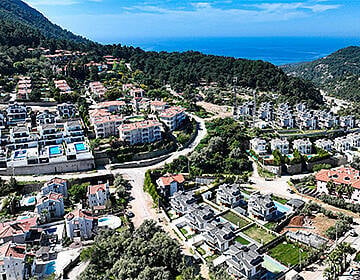
In 1982, Akdeniz University was established and the population of the city increased to 280.000 during these years. The slums continued to concentrate in the north of the city and during this period the zoning plans of the city were changed many times. Since 1980, four different zoning plans had been prepared, in contradiction with the previous zoning plan, the Lara region had been removed of the coverage of being a protected area, and another zoning plan in 1992 foresaw the establishment of a satellite city by shifting the population to the north in order to protect the fertile agricultural lands. Tourism investments in this period and frequently changed plans disrupted the natural and cultural structure of the city, agricultural areas were opened to housing and the protected areas were narrowed. In 1996, important buildings such as Glass Pyramid Congress Center, Bus Terminal, Antalya Culture Center were built and tourist attractions in the city were diversified during this period. In 2000, the population of the city increased to 936,000 and the population of the whole province increased to 1,719.00. Today, the center of Antalya has spread to the Hurma neighborhood in the west, Kepez in the north, Örnekköy in the south and to Aksu in the east. According to the 2017 census, 2.364.396 people live in Antalya and 1.251.523 people live in the city center.
My purpose in writing this article is to criticize some of the topics that disturb me very much such as, the architectural texture of our cities not being preserved, unsupervised urbanization, the inability to fulfill the responsibility of leaving the cultural heritage of the societies that lived before us in this land to the future, monuments or pieces of art being damaged or lost due to restoration errors and ancient structures crumbling to pieces because of neglection through the example of Antalya. A number of miscalculated decisions taken in the years of Turkey’s rural-urban migration and an explosive increase in the population changed not just Antalya, but every Turkish city drastically. This situation has grown like an avalanche due to the inability of the local administrations being unable to make the necessary actions and improper fulfillment of the increasing housing needs starting in the 1950s. This urbanization process starting in the bigger cities formerly, later spread to every Anatolian city no matter the size, becoming a norm in Turkey’s sense of urbanization and slowly digested our beautiful country’s diverse cultural textures just like in Antalya.
Sometimes I wonder what kind of a city Antalya would be if the texture of the old city was preserved. I see the palms on Işıklar Avenue and the two-story tiled roof houses behind them. I see a flock of waterfalls flowing through the cliffs. I see the Three Doors, the floor is covered with glass, they see the thousands of years old stones under their feet from the top of the glass, somehow, they still stand for centuries, with not even one nail on them. Even the fruit trees in the courtyards of the traditional houses of Kaleiçi still stand. The old houses in Kapıyol are not covered with irregular signs that create color pollution. Even though we are aware that we are late for many things, we should still take care of our neighborhoods, settlements, cities and the livability of our country in general and follow a protective policy.
* Source: Deren Güzel Tekçe, Toplumsal Tarih, 306 / June 2019, P:76-79
More Information about Antalya
• Holiday Resorts in the Antalya Region of Turkey: Discover Antalya, backed by the Taurus mountain range and fronted by the turquoise blue sea.
• Ten Reasons why Antalya Expats Like Living Here: Why do various nationalities expats prefer Antalya to others in Turkey?
• The Best Things to Do in Antalya: Pursuing the full range of places to see, do, and go is cheap, cheerful, and excellent value for money.
• Good Reasons to Visit Antalya in Mediterranean Turkey: Antalya is the Turkey's Blue Paradise thanks to great beaches and tourism potential. So, what exactly is it about Antalya that draws in the crowd.


